

















How to verify an RV route across a seasonal mountain pass
A four-proof workflow for checking a seasonal mountain-pass gate, live closures, RV-specific vehicle rules and a safe alternate before departure.

Source note: This RVCamping.info planning method uses 2026 WSDOT, CDOT and National Park Service examples. Conditions and restrictions can change without matching a historical opening date. Check the agencies responsible for every segment immediately before travel.
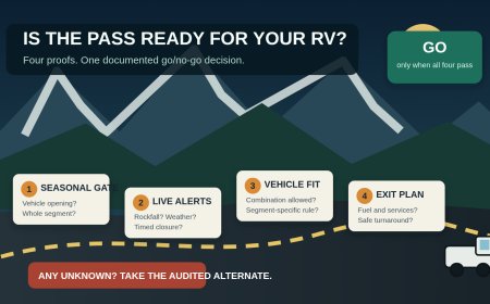
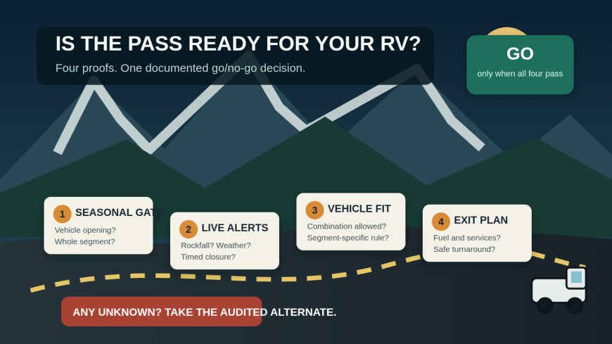
A mountain pass belongs on an RV itinerary only after four separate checks: the seasonal gate is open, no temporary closure blocks the travel window, the complete RV combination is allowed, and the approach plus exit still work. "Open" answers only the first question.
That distinction catches the failure a normal route preview misses. Washington reopened Chinook and Cayuse passes for the 2026 season on May 22, but the same notice says commercial vehicles are prohibited on the portions of SR 410 and SR 123 inside Mount Rainier National Park.[1] Glacier's alpine road may be open while an RV is too long or wide for its central section.[2] Colorado can open Independence Pass while keeping a length restriction in force.[4]
Use the workflow below to turn a map line into a documented go, reroute or wait decision. It is intentionally narrower than a general RV clearance check. The job here is to prove one mountain corridor on one travel date, including its seasonal gate, jurisdiction changes and pass-specific rules.
Start with a pass dossier, not a forecast
Create one page for each pass under consideration. Put the exact route number and endpoints at the top. A familiar pass name is not precise enough because a state highway can cross park land, and different agencies may control the road, gate, facilities and vehicle rule.
Record these fields:
- planned entry and exit, including the direction of travel;
- travel date and a two-hour arrival window at the pass;
- RV length by itself and total connected length while towing;
- whether the registration or use could place the vehicle in a commercial category;
- every agency that controls a segment;
- official current-conditions page, pass page and alert feed;
- the last suitable turnaround before each controlled segment;
- a fully checked alternate route;
- the time and result of each verification.
Keep measurements in the units used by the rule. Do not round a 35-foot combination down to "about 34." Measure the configuration that will cross the pass, including bumpers and attached towing equipment when the agency's wording includes them.
Draw the corridor as separate segments
Break the drive at every gate, junction and jurisdiction boundary. A useful segment table has five columns:
| Segment | Owner | Seasonal status | RV rule | Exit or turnaround |
|---|---|---|---|---|
| Approach highway | State DOT | Open/closed/unknown | Applicable state restrictions | Last major junction |
| Park or summit road | DOT, park or both | Open/closed/unknown | Length, width, class or trailer rule | Last legal pullout |
| Downhill leg | State DOT or county | Open/closed/unknown | Temporary controls and local restrictions | First safe alternate junction |
| Campground approach | Park, county or private owner | Open/closed/unknown | Road and campground limits | Check-in contact |
This prevents one green status symbol from being stretched across the whole drive. WSDOT's 2026 notice explains that parts of SR 410 and SR 123 lie inside Mount Rainier National Park and that WSDOT maintains those highway sections under an agreement with NPS.[1] That is exactly the sort of shared corridor where a traveler should check both the road agency and the land manager.
Mark an unchecked cell unknown, never "probably open." Unknown is a stop condition until an official source resolves it.
Run four proofs in order
Proof 1: Is the seasonal gate open for vehicles?
Use the current agency status, not a search-result date, campground opening or historical average. Glacier says the alpine part of Going-to-the-Sun Road has no fixed opening date; snowfall and plowing progress determine it, and weather can close portions after opening.[2] A typical season is useful for deciding when to research. It is not permission to drive.
Yosemite's 2026 update shows why the status must be specific to vehicle access. It announced Tioga Road would open to all traffic at 8 a.m. on May 15, after a separate day of bicycle access.[3] A plowing update, a bicycle opening or a photo of bare pavement does not prove that the public vehicle gate is open.
Write one of three verdicts in the dossier:
- GO: the official page says the complete segment is open to public vehicles during the planned window;
- WAIT: the gate is closed or the agency has not announced a vehicle opening;
- UNKNOWN: the official status is stale, unclear or covers only part of the corridor.
Proof 2: Is there a shorter-lived closure or control?
After confirming the seasonal opening, check the DOT incident map, park alerts and forecast for the same arrival window. Look for avalanche work, rockfall, wildfire response, storm closures, construction closures and chain controls. A pass can be open for the season and closed for an afternoon.
Capture the issue's location, direction, start time and expected reopening. "Road work on the pass" is not enough to decide whether the RV can reach the last turnaround before crews close the gate.
If the notice gives no firm reopening time, do not build a campground arrival around the optimistic edge of the estimate. Move the pass crossing earlier, take the verified alternate or change the overnight stop.
Proof 3: Is this exact RV combination allowed?
Now apply the pass-specific rule. This is not a general bridge-clearance exercise. Focus on restrictions written for the named mountain segment: total or combined length, trailer prohibition, width, vehicle class, permit, timed access or direction.
Glacier bars the Avalanche Creek-to-Rising Sun section to any rig exceeding 21 feet bumper to bumper or 8 feet across at the mirrors. It also warns that a height above 10 feet can be troublesome west of Logan Pass because rock projects over the road.[2] An RV that fails the central segment can still use park roads outside that segment if those approaches pass their own checks; crossing Logan Pass in the RV is not the only way to visit.
CDOT's May 2026 Independence Pass notice draws the line at 35 feet in its heading and first description. The body then uses "more than 35 feet" when discussing the truck-or-RV plus its trailer as one measurement.[4] Those phrases leave 35 feet itself unclear. Use the stricter reading, treat 35 feet as prohibited, and ask CDOT before departure if the measured combination is on the boundary. Never resolve conflicting wording in your favor from the driver's seat.
A restriction on "vehicles and trailers with a combined length" means the tow combination is the screening number. A 27-foot motorhome towing a 15-foot car is not a 27-foot vehicle for that test.
Proof 4: Can the RV complete the leg without relying on closed services?
An open gate does not promise fuel, water, food, dump facilities, campgrounds or a place to wait. Yosemite opened Tioga Road on May 15, 2026 with vault and portable toilets but no drinking water and no other services along the road.[3] That would be a valid crossing for a prepared RV and a poor place to discover an empty fresh-water tank or assume a store has opened with the pavement.
Check fuel range from the last reliable stop to the first verified stop beyond the pass. Confirm campground access separately. Record where the RV can legally wait if the pass closes after departure. If the only fallback is reversing a long combination at a locked gate, the route is not ready.
Use a three-check schedule
A single screenshot taken when the reservation is made goes stale. Verify the dossier at three points:
- Planning check, 7 to 14 days before travel. Identify agencies, rules, seasonal status, services and the alternate. This is when to change reservations without pressure.
- Commit check, the evening before. Refresh every official status and alert page. Recalculate fuel and arrival time. Save the current notices for weak-signal areas.
- Departure check, immediately before moving. Reopen the live DOT and park status pages. Check weather and new incidents. If another adult is traveling, have that person read the pass verdict aloud while the driver is parked.
Add a fourth check at the last service town when conditions are changing. The passenger can refresh pages while stopped. The driver should not troubleshoot conflicting notices while moving.
For each check, log the timestamp, URL and exact verdict. A useful entry reads:
2026-09-13 06:10 MDT — CDOT notice and live road map checked. Seasonal gate: open. Temporary closure: none shown. Combination length: 38 ft. Independence Pass: NO-GO under the published 35-ft restriction. Alternate remains US 24/I-70; fuel stop confirmed before diversion.
That note preserves the reasoning. "Checked CDOT" does not.
Test the alternate as a separate route
Do not accept the navigation app's first detour as the fallback. Build a second dossier for the alternate and run the same four proofs. A lower highway may avoid the seasonal gate yet add a tunnel rule, a construction closure or a campground approach that does not suit the RV.
The alternate should diverge before the last safe decision point. Record the extra distance, fuel requirement, travel time and overnight options. If both routes depend on the same avalanche zone or junction, they are not independent fallbacks.
Set a decision time. For example: "If the pass is not confirmed open by 7 a.m., leave on the alternate; do not wait at the gate." This prevents a hopeful delay from turning into a night arrival on an unfamiliar mountain road.
Work through two sample decisions
A 24-foot motorhome at Glacier
The alpine section is reported open, but the motorhome is longer than Glacier's 21-foot limit between Avalanche Creek and Rising Sun.[2] The pass verdict is NO-GO for the RV, even though the road-status proof passes. The trip can be redesigned around an allowed approach, a suitable campground outside the restricted section and park transportation, subject to current operating details.
A 34-foot fifth-wheel combination at Independence Pass
Suppose "34-foot fifth wheel" describes only the trailer body, while the connected truck-and-trailer measurement is 55 feet. CDOT applies its Independence Pass wording to the combined vehicle and trailer length.[4] The verdict is NO-GO. Detaching near the gate is not a route plan unless there is a legal, authorized place to store the trailer and every separate movement is allowed.
These examples expose a useful rule: test status and fit independently. An open pass can reject the RV. A suitable RV cannot cross a closed gate.
Stop when the evidence does not line up
Use NO-GO when any official rule excludes the rig, any required segment is closed, the alternate is unverified, or the driver would pass the last safe turnaround before resolving an unknown. Call the responsible agency when:
- two official pages disagree;
- a restriction does not define whether length is vehicle-only or combined;
- the RV's registration or use makes a vehicle-class rule ambiguous;
- an alert names a milepost you cannot place relative to the gate;
- the page has no update time and conditions are changing.
Record the agency, phone number, time and answer. A phone answer can clarify wording, but posted signs, a closed gate and on-scene direction still control when you arrive.
The route decision should fit on one line
Finish the dossier with one sentence:
GO via [pass] only if [seasonal gate], [temporary condition], [vehicle rule] and [service/exit plan] all remain verified at [departure time]; otherwise use [audited alternate] before [decision point].
That line is more useful than a folder of screenshots. It tells the crew what must remain true, when to check it and where to go if one proof fails.
Sources
What's Your Reaction?