






The RV route-clearance call sheet: verify tunnels, bridges, and park roads before you leave
Build a practical RV route-clearance call sheet for tunnels, low bridges, park-road size limits, propane checks, last safe exits, and verified detours.

The RV route-clearance call sheet: verify tunnels, bridges, and park roads before you leave
By Romana
A route line on a phone proves only that roads connect. It does not prove that your motorhome, fifth-wheel, travel trailer, rooftop air conditioner, mirrors, propane system, or combined length fits every road on that line.
The useful pre-trip question is not "Does the map offer a route?" It is "Which agency controls each choke point, what dimensions does that agency use, and who will confirm the rule for my exact rig and travel date?" Generic GPS directions are not sufficient for that job. PennDOT specifically tells RV drivers not to rely only on navigation devices because they may not account for vehicle height; its 511PA service has a Low Bridge layer for clearances below 13 feet 6 inches.[4]
This guide turns that warning into a call sheet you can complete before departure. It covers permanent dimensions, temporary restrictions, tunnel procedures, and the awkward details that a single height field cannot capture.
Start with a measured rig card
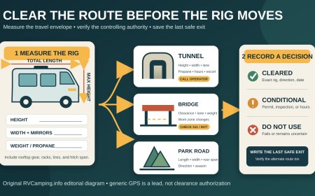
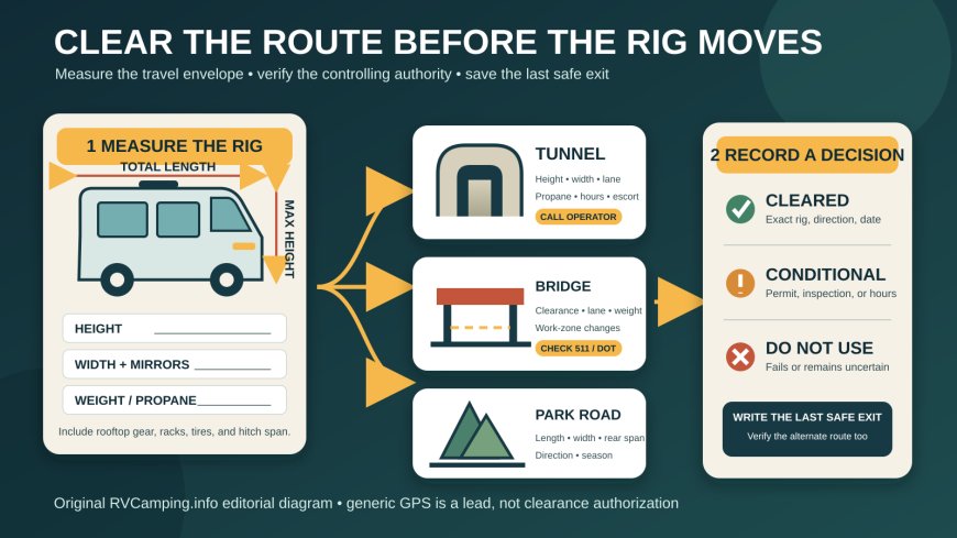
Do not copy the brochure's exterior height and call the job finished. Measure the travel-ready vehicle on level ground, or have a qualified shop do it. Record the highest fixed point, often an air conditioner, vent, antenna, solar component, or satellite dome. Include anything added after delivery.
Write down these figures:
- total height in normal travel configuration;
- body width and maximum width including mirrors;
- motorhome or tow-vehicle length;
- trailer length, measured the way the road authority specifies;
- total combination length from the front of the tow vehicle to the rearmost attachment;
- gross and axle weights from a recent loaded weighing;
- propane container count, capacity, valve status, and whether containers are permanently mounted or portable;
- rear overhang and hitch-to-rear-axle distance when a park or agency uses either measurement.
That last detail is not theoretical. Zion National Park counts mirrors, tires, air conditioners, bike racks, satellite dishes, and other modifications in its measurements. Its current Zion-Mt. Carmel Highway limits include 35 feet 9 inches for a single vehicle, 50 feet total for a combination, 7 feet 10 inches wide, 11 feet 4 inches high, and 50,000 pounds. A trailer in a combination is also limited to 26 feet from hitch to rear axle.[1]
Keep the rig card in the cab and as a photo on both travelers' phones. If you swap the rooftop unit, add a cargo box, mount bicycles, or change trailers, measure again.
Mark choke points, not just destinations
Audit the route at the level of named roads and structures. Start at the campground and work outward. Look for:
- 1. the campground entrance road and any private bridge;
- 2. park roads, scenic drives, tunnels, rock overhangs, and entrance-station limits;
- 3. state and local bridges, underpasses, posted weight limits, and restricted parkways;
- 4. toll bridges and tunnels with propane or inspection procedures;
- 5. construction detours, because a legal main route can be replaced by a road that does not fit the rig.
Put every questionable segment on the call sheet, even if an RV routing app accepts it. The app is a useful discovery tool. The controlling agency and roadside signs settle the question.
Also trace the escape before the restriction. A safe plan identifies the last legal turn, large parking area, fuel stop, or campground where the driver can stop without backing into traffic. "Turn around at the tunnel" is not a plan for a 48-foot combination.
Official examples show why one clearance number fails
Zion's rule covers the full highway corridor from Canyon Junction through the East Entrance, rather than only the Zion-Mt. Carmel Tunnel. The corridor combines curves, switchbacks, a tunnel, and four bridges. A rig can fail by length, width, height, weight, or hitch-to-rear-axle distance even when its roof would clear the tunnel.[1]
Glacier National Park uses another boundary. The restricted stretch of Going-to-the-Sun Road runs from Avalanche Creek to Rising Sun. NPS bars a vehicle or connected combination there if its bumper-to-bumper length exceeds 21 feet or its mirror-to-mirror width exceeds 8 feet. The park also warns that westbound travel from Logan Pass toward the Loop can be difficult above 10 feet because of rock overhangs.[2] A compact trailer might pass the height check and still fail the combination-length rule.
Yosemite adds direction and lane position to the problem. NPS lists the Wawona Tunnel clearance at the curb as 10 feet 2 inches entering Yosemite Valley and 13 feet 6 inches leaving it, while noting that the clearance at the white fog line is higher. Big Oak Flat Road's tunnels are listed at 10 feet 3 inches from Yosemite Valley and 13 feet 8 inches into the valley. Elsewhere in the park, Hetch Hetchy Road limits vehicles to 25 feet long and 8 feet wide mirror to mirror.[3] A note that merely says "Yosemite tunnel: OK" throws away the direction, location, and width data the driver needs.
State systems bring a different set of tools. PennDOT says bridges below 14 feet 6 inches are signed with low-clearance warnings, and 511PA's Low Bridge layer identifies structures below 13 feet 6 inches.[4] Those values do not create a universal RV allowance. They describe Pennsylvania's signing and map practices. Your call sheet must retain the state, route, direction, and source date.
Tunnel rules can also involve fuel systems rather than geometry. VDOT says motorhomes must stop for a propane-tank check before going through Hampton Roads tunnels and directs travelers to current 511 information. The agency's published number is 800-367-7623.[5] "Height clears" is therefore only one line of the tunnel decision.
The pre-trip clearance call sheet
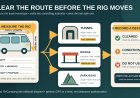
Complete one row for every choke point. Call during weekday business hours when possible, then check the agency's travel-alert page again shortly before departure.
| Field | What to record |
|---|---|
| Trip and leg | Date, origin, destination, planned arrival window |
| Exact location | State, route number, direction, milepost or named bridge/tunnel/park segment |
| Controlling authority | State DOT, toll authority, NPS unit, county, city, private campground, or concessioner |
| Official page | Full URL and the date you checked it |
| Contact | Office, phone number, hours, and staff member or reference number if supplied |
| Rig identity | Motorhome or tow vehicle plus trailer; plate numbers if the authority requests them |
| Travel dimensions | Height, width with mirrors, single and combined length, hitch-to-rear-axle distance, loaded weight |
| Restriction details | Posted clearance, width, length, weight, lane, direction, hours, inspection, permit, reservation, or escort |
| Propane/hazmat | Tank type, number and capacity; shutoff or inspection requirement; prohibited quantity if stated |
| Temporary conditions | Work zone, paving, snow gate, closure, detour, timed access, pilot car, or one-lane operation |
| Decision | Cleared as stated, conditional, or do not use |
| Last safe exit | Exit number or junction before the restriction and a stop large enough for the full rig |
| Alternate route | Road-by-road alternative confirmed for the same dimensions |
| Recheck | Date, time, official alert source, and person responsible |
Read this script when you call
"I am planning to travel [route and direction] on [date and approximate time] in a [motorhome / tow vehicle and trailer]. In travel configuration it is [height] high at the highest fixed point, [width] wide including mirrors, [single or combined length] long, and [loaded weight]. The trailer measures [hitch-to-rear-axle distance] if that applies. It carries [propane details]. May this exact vehicle use [named structure or road segment]? Are there lane, direction, inspection, escort, permit, hour, construction, or detour restrictions? If not, where is the last safe turn and which alternate route should I verify?"
Ask the official to define how each measurement is taken. "Trailer length" may mean body length on one page and hitch-to-rear-axle distance on another. Ask whether mirrors, awnings, ladders, bicycles, spare tires, and roof equipment count. If the answer is uncertain, request the office that owns the structure or enforces the restriction.
Use a two-pass verification routine
The first pass happens while the itinerary is still flexible. Check every jurisdiction's official restriction page, 511 system, park alerts, and toll-facility rules. Call about ambiguous entries and build the alternate route. Save a PDF or screenshot for reference, but write the page's retrieval date on the sheet because saved information can age.
The second pass happens 24 to 48 hours before travel, then again before leaving if weather or construction is active. Confirm that the named road remains open and that no detour has replaced it. A detour must be checked as a new route, not accepted because an official sign points toward it. If a roadside restriction is lower or stricter than your research, obey the sign and stop in a safe place.
Do not make clearance decisions while approaching the obstacle. The passenger can monitor alerts, but the driver should already know the last safe exit. If the answer changes, take the verified alternate or stop and call. Never creep under a low structure, straddle lanes, move cones, use the shoulder for extra height, or assume the center of an arched tunnel is available unless the authority has explicitly established that operating procedure.
A completed line should produce a decision
A useful row ends with one of three results:
- Cleared: the official rule covers the exact rig, direction, date, and operating procedure.
- Conditional: passage depends on an inspection, ranger traffic control, time window, permit, lane, escort, or current opening. Record every condition.
- Do not use: one dimension fails, the agency cannot confirm passage, or the alternate has not been checked.
"Probably fine" is not a fourth result. Neither is "other RVs use it." The examples above show how quickly a route changes when the controlling measurement shifts from height to mirror width, total combination length, weight, direction, or propane procedure.
Print the finished sheet, place it with the rig card, and give the alternate-route line the same attention as the preferred road. A good clearance plan does not try to make the RV fit. It finds a road that already does.
Sources
What's Your Reaction?