








Tahquamenon Falls RV Camping: Lower Falls or Rivermouth?
A rig-first comparison of Lower Falls and Rivermouth modern campgrounds, with a supported Hemlock-versus-Portage decision inside Lower Falls.

Tahquamenon Falls RV camping: Lower Falls or Rivermouth?
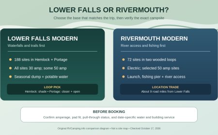
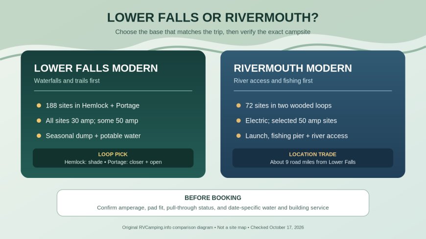
Tahquamenon Falls State Park is long enough that choosing a campground changes the trip. Lower Falls Modern Campground puts an RV near the cascades and the trail system.[1] Rivermouth Modern Campground trades that proximity for a wooded base near the Tahquamenon River's downstream access, roughly nine road miles from Lower Falls on the official park map.[1][4]
For most first visits centered on the waterfalls, Lower Falls is the practical choice. Pick Rivermouth when paddling, fishing, boating access, or a quieter river-end base matters more than walking or making a short hop to Lower Falls. Both are modern campgrounds with electric service, showers, sanitation stations, and some 50-amp inventory, but the exact electrical amperage, driveway, surface, and availability still belong to the individual reservation record.[1][2][3]
The short comparison
| Decision point | Lower Falls Modern | Rivermouth Modern |
|---|---|---|
| Best trip shape | Waterfalls, trails, and repeated Lower Falls visits | River access, paddling, fishing, and a base south of Paradise |
| Official site count | 188 | 72 |
| Electric service | All sites have 30 amp; some 50-amp sites | Electric service; some 50-amp sites |
| Campground character | Two distinct loops: shaded Hemlock and more open Portage | Wooded, two-loop campground |
| Dump and potable-water plan | Seasonal two-lane sanitation station | Seasonal two-lane sanitation station |
| Shower/toilet building | Modern facilities; Hemlock building open year-round | Modern facilities shown for the campground; verify seasonal operation for the dates |
| Winter distinction | Hemlock open year-round; Portage becomes hike-in camping in winter | No year-round operating promise stated on the park campground entry |
| Water access | Carry-in launch in the Lower Falls day-use area | Carry-in access at the modern campground; boat launch nearby |
The table narrows the search. It does not promise that a 50-amp, pull-through, paved, accessible, or river-view site will be open on a particular night. The official maps show that these features apply to selected sites, not the whole campground.[2][3] Enter the real travel dates and equipment in the Michigan reservation system, then inspect the selected site's record before paying.
Choose Lower Falls when the falls are the point
The park describes Lower Falls as a series of cascades around an island.[1] The campground has 188 sites split between Hemlock and Portage.[1] That is the obvious base for an itinerary with several Lower Falls visits, short walks, or trail time rather than a daily drive back from the river mouth.
Lower Falls also has the clearest published electrical statement: every campsite has 30-amp service, with some 50-amp sites.[1] That distinction matters. A search result labeled "electric" is not enough for a rig that needs 50 amps. Filter for the required service and confirm it on the site detail page. Do not assume a 30-amp adapter gives a 50-amp coach the same available power.
The campground's sanitation station is seasonal.[1] Michigan DNR says the Lower Falls and Rivermouth modern stations generally operate from mid-May to mid-October, each with potable water and two lanes.[1] Noncampers pay a stated $10 use fee.[1] Treat those dates as an operating pattern rather than a guarantee: freezing weather and local conditions can affect water service. A shoulder-season reservation needs a direct check with the park.
Lower Falls is the stronger choice when:
- the falls will anchor more than one day;
- trail access from camp is useful;
- a year-round option matters and Hemlock has a suitable site;
- the rig needs a published 30-amp baseline; or
- the larger 188-site inventory improves the odds of finding an exact fit.
Hemlock or Portage inside Lower Falls?
The two Lower Falls loops do not feel interchangeable on paper. Hemlock is about a mile from Lower Falls, more shaded, and connected to the park trail system.[1] Michigan DNR lists it as open year-round and says its accessible toilet and shower building stays open all year.[1]
Portage is closer to the river and about a quarter-mile from Lower Falls.[1] It is generally sunnier and more open, has some river-view sites, provides North Country Trail access, and includes an accessible modern toilet and shower building plus some accessible campsites.[1] In winter, Portage changes to hike-in camping.[1] That is not normal drive-up RV availability.
Choose Hemlock for shade, year-round drive-up camping, or direct trail-system access. Choose Portage for the shorter Lower Falls position, a more open site, or a chance at a river view. Those are loop-level tendencies, not guarantees for every pad.
The official Lower Falls map adds useful site-level clues. It marks selected 50-amp, pull-through, and ADA-compliant sites, shows water points, and places the sanitation station toward the park entrance.[2] It also shows Portage sites 1 through 82 near the river and directs campers another half-mile to sites 101 through 188, the Hemlock inventory.[2] Use the map to build a shortlist, but let the live reservation record settle equipment length, occupancy, and availability.
Choose Rivermouth for a river-based stay
Rivermouth Modern has 72 sites in two wooded loops.[1] Michigan DNR notes a mix that includes selected accessible, paved, and pull-through sites.[1] The campground entry lists electric service, some 50-amp sites, a modern toilet and shower building, a sanitation station, and recycling.[1] Its map separately marks the 50-amp and pull-through sites, which is another reason not to treat either feature as campground-wide.[3]
The location changes the trip. The park's paddling description covers 17 river miles from Lower Falls to Rivermouth, with carry-in access at both ends.[1] An accessible paved boat launch and fishing pier sit near Rivermouth, and the modern campground has carry-in access.[1] That makes Rivermouth a better planning base for a paddling shuttle, a fishing day, or repeated use of the downstream access.
Rivermouth is not a waterfall campground by another name. The official park map places it about nine miles from Lower Falls by the marked corridor.[4] Campers who expect to spend every morning and evening at the falls will add driving. Campers who want the river mouth, Whitefish Bay side trips, or proximity to Paradise may prefer that trade.
Rivermouth is the stronger choice when:
- the boat launch, fishing pier, or carry-in river access drives the itinerary;
- a smaller wooded modern campground sounds better than the 188-site Lower Falls complex;
- selected paved or pull-through inventory is important; or
- repeated waterfall access is less important than downstream river access.
Do not confuse Rivermouth Modern with Rivermouth Rustic
The park lists two separate Rivermouth campgrounds.[1] Rivermouth Modern has 72 sites and electrical service.[1] Rivermouth Rustic has 36 sites along the river and is described as better suited to tents, vans, or compact campers because of its sandy sites and open understory.[1]
The rustic campground is seasonally semi-modern.[1] DNR's usual water window starts in mid-May and ends on October's second Sunday, if temperatures permit.[1] While water is on, rustic campers may use the modern campground's restroom and shower building; it is roughly ten minutes on foot or a brief drive.[1] When that building closes and the spigots shut down, Rivermouth Rustic operates as a true rustic campground.[1]
A reservation search containing "Rivermouth" therefore needs one extra check: confirm that the result says Modern, not Rustic. This article's service comparison applies to Rivermouth Modern.
Verify the exact site, not the campground label
Michigan's maps identify feature categories but do not replace a site record. Before booking, check:
- campground and loop name, especially Modern versus Rustic and Hemlock versus Portage;
- electrical amperage at the site;
- driveway length, width, surface, grade, and back-in or pull-through entry;
- enough in-boundary room for the camping unit and every accompanying vehicle;
- accessibility designation if required;
- sanitation station, potable water, restroom, and shower operation for the actual dates; and
- current alerts plus the route into the selected campground.
Michigan's general campground rules allow one primary camping unit and no more than six people per campsite.[5] The vehicle allowance depends on the combination brought to the site, and all equipment must remain within the site boundary.[5] Measure the full camping arrangement instead of searching only by trailer or motorhome body length.
Generators and other amplified devices must stay quiet during the statewide campground quiet period, 10 p.m. to 8 a.m.[5] Electric service reduces the need to run one, but it does not fix a mismatch between a 50-amp coach and a 30-amp site. Plan loads before arrival.
A simple choice
Book Lower Falls Modern for a waterfall-first trip. Within it, start with Hemlock for shade and year-round drive-up use; start with Portage for a more open loop closer to the river and Lower Falls.[1]
Book Rivermouth Modern for a river-first trip with paddling, fishing, or boating access. It still provides modern facilities and electric inventory, but its smaller site pool and selected 50-amp and pull-through features make exact-site checking important.[1][3]
Availability and services are date-specific. Run a fresh reservation search, open the individual site record, and call the park at 906-492-3415 when shoulder-season water or building status could decide the stay.[1]

Sources
- Tahquamenon Falls State Park — Michigan DNR — Official campground descriptions, site counts, service statements, seasonal sanitation details, water access, addresses, and park contact. Retrieved October 17, 2026.
- Lower Falls Modern Campground map — Michigan DNR — Loop layout and selected 50-amp, pull-through, accessible, water, restroom, and sanitation features. Retrieved October 17, 2026.
- Rivermouth Modern Campground map — Michigan DNR — Site layout and selected 50-amp, pull-through, accessible, water, restroom, and sanitation features. Retrieved October 17, 2026.
- Tahquamenon Falls State Park map — Michigan DNR — Park geography and marked Lower Falls-to-Rivermouth distance. Retrieved October 17, 2026.
- Michigan state park rules and regulations — Michigan DNR — Campsite occupancy, camping-unit and vehicle limits, quiet hours, and general campground rules. Retrieved October 17, 2026.
What's Your Reaction?