




Glacier east-to-west by RV: when US 2 is the through route
Measure the connected RV first, then budget Glacier's 90-mile US 2 route, fuel and cold-season campground limits.

Glacier east-to-west by RV: when US 2 is the through route
By Romana
Going-to-the-Sun Road looks like the direct line between Glacier National Park's west and east sides. For most RV trips, it is not a through route at all. A 21-foot vehicle-combination limit removes many motorhomes and nearly every truck-and-trailer combination before weather enters the decision. By late October, the alpine section is normally closed anyway.
Source credit: This size-first route model uses current National Park Service distance, restriction and seasonal-access guidance plus Montana's official 511 service.
Start with the combination length
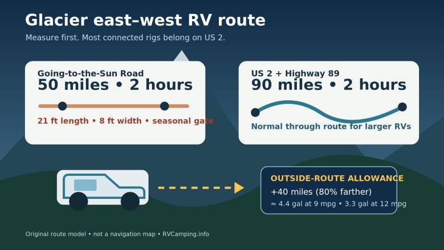
Between Avalanche Creek and Rising Sun, the prohibition applies when a vehicle alone or a connected combination exceeds 21 feet in length or 8 feet in width. NPS counts bumpers in the length and mirrors in the width. Vehicles taller than 10 feet may also have trouble with rock overhangs west of Logan Pass.[1]
"Combination" is the important word for a towable. A 19-foot trailer behind a pickup is not a 19-foot vehicle for this rule. Measure the pickup and trailer as one connected unit from the frontmost point to the rearmost point. If the result exceeds 21 feet, the alpine section is off the route even when every gate is open and pavement is dry.
The same test catches larger vans and short motorhomes: length, mirror-to-mirror width and actual height each need their own pass. One compliant dimension does not cancel another failure.
The detour is 40 miles, not necessarily extra driving time
NPS publishes two West Glacier-to-St. Mary options:
| Route | Published distance | Published drive time | RV use |
|---|---|---|---|
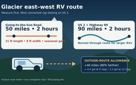
| Going-to-the-Sun Road | 50 miles | 2 hours | Only when fully open and the complete vehicle fits the 21 ft / 8 ft / height constraints |
| US 2 to Highway 89 | 90 miles | 2 hours | The normal through route for larger RVs and towables; current conditions still control |
The arithmetic is simple: US 2 adds 40 miles, an 80 percent distance increase. Yet the park gives both routes a two-hour estimate.[1] The shorter mountain road is slow, narrow and stop-prone; distance alone exaggerates the practical time saving.
For fuel planning, add the detour mileage to the day's budget. At 9 mpg, 40 miles consumes about 4.4 gallons. At 12 mpg, it consumes about 3.3 gallons. Those figures are planning allowances, calculated as 40 divided by the RV's expected miles per gallon, not forecasts of actual consumption. Grade, temperature, wind and idling will change the result.
Late October makes the size test universal
The park says the alpine sections usually close for winter around the third Monday in October, with an earlier closure possible in winter weather. Lower sections remain accessible from their respective sides.[1] On October 26, an itinerary should therefore treat West Glacier and St. Mary as separate road approaches unless the live NPS road-status page explicitly shows otherwise.
This is the useful distinction:
- A rig over the size limit uses US 2 and Highway 89 in every season.
- A smaller rig may use Going-to-the-Sun Road only during the full-opening period and only after a same-day status check.
- Once the alpine section closes, every vehicle making the west-to-east transfer needs the outside-park route.
Do not mistake year-round access at the road's west end for a cross-park opening. NPS says complete access over the alpine section usually arrives no earlier than late June.[1]
Choose one base in cold season
Apgar is the one documented in-park frontcountry option for the November period. NPS says Loop B is first-come, first-served primitive camping, with a vault toilet but no running water or flush toilets; camping becomes free November 1.[4] The same November guidance says the road from West Glacier to Avalanche Creek remains open weather permitting through mid-December, then the vehicle closure moves to Lake McDonald Lodge.[4]
That service level changes the trip design. An east-side day trip from Apgar is a 180-mile round trip by the published outside route. At 9 mpg, that is a 20-gallon travel day before local mileage. Unless a specific east-side objective justifies it, moving the RV across the park for a single day is poor cold-season logistics.
A better plan is usually one of these:
- Stay at Apgar and concentrate on the open west-side road and Lake McDonald corridor.
- Book a separate east-side commercial base and make the 90-mile transfer once.
- Put both sides on the itinerary only if weather, daylight and an open overnight option support the transfer.
The park's general camping page lists reservation campgrounds for the main season but also warns that availability must be checked through Recreation.gov.[3] A summer campground name on a map is not evidence of an October operating date.
A departure-day gate sequence
Run the checks in this order:
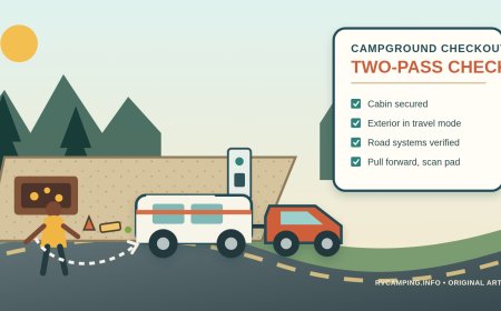
- Measure. Record connected length, mirror width and loaded height. If any number fails the park restriction, delete Going-to-the-Sun Road from the route before checking weather.[1]
- Check the NPS road status. The current-conditions page is the source for park closures; conditions can change quickly.[2]
- Check US 2 and Highway 89. Montana 511 reports weather-related conditions, work, closures, chain requirements and restrictions for U.S. and state highways.[5]
- Recalculate daylight and fuel. Use 90 miles for the transfer, not 50, and keep reserve for a weather retreat.
- Verify the night's campsite. Confirm that the campground is open for the exact date and that the exact site fits the connected rig.
Montana notes that cell reception can be poor and provides 800-226-7623 as an alternative to dialing 511.[5] Save the number and the last road report before leaving service.
The route decision in one line
If the connected RV is over 21 feet, wider than 8 feet, or too tall for the overhang warning, use US 2 and Highway 89. If it fits, the alpine road still requires a full-opening confirmation. In late October, plan on the 90-mile outside route and let a live status report improve the plan, rather than letting an old summer map break it.
Sources
- National Park Service — Glacier directions, transportation and road conditions (accessed October 26, 2026)
- National Park Service — Glacier current conditions (accessed October 26, 2026)
- National Park Service — Glacier camping information (accessed October 26, 2026)
- National Park Service — Visiting Glacier in November and early December (accessed October 26, 2026)
- Montana Department of Transportation — About 511 (accessed October 26, 2026)
What's Your Reaction?