












When the Signal Quits: Build an Offline RV Route Card
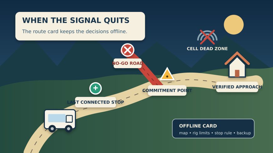
Build an offline RV route card that joins downloaded official maps, rig limits, a last connected stop, a commitment point, and a verified backup.

When the Signal Quits: Build an Offline RV Route Card
By Romana | October 9, 2026
The navigation screen goes blank ten miles from camp. The route had looked easy at breakfast, but now the road has forked, the campground entrance is still somewhere ahead, and a U-turn would be ugly with a trailer.
This is a planning failure, not a signal failure. A downloaded map helps, but it does not remember your rig height, tell you which turn is the last safe decision point, or prove that a public-land road is open to your vehicle today. Before an RV travel day enters weak coverage, make one offline route card that joins the map, the rig limits, and the current-condition check.
Source note: This guide is an original RVCamping.info route-planning article based on official NPS, BLM, and Ready.gov material. The prior 90-day publication manifest was parsed before selection. Existing pieces address cell coverage, road-condition checks, remote fuel, weather checkpoints, construction, clearances, grades, and railroad crossings. None uses an offline route card to manage the loss of live navigation itself.
A saved map is only one layer
The NPS app lets a traveler download a park for offline use. The same app has an interactive map and lets users create lists of saved places. NPS says to download the park before leaving home, preferably on strong Wi-Fi.[1] That solves an important problem: the downloaded park map remains available after data service disappears.
It does not make the map current forever. Grand Canyon's NPS instructions say most downloaded park content works offline, but real-time updates are an exception.[3] An offline map may still show where the entrance road runs while missing the closure, fire restriction, construction change, or temporary gate schedule that should alter today's plan.
BLM georeferenced PDFs add another useful layer. On a GPS-enabled device, a compatible app can show the traveler's location on a downloaded map without cellular reception.[2] BLM also warns that GPS accuracy can suffer near tall cliffs and in slot canyons, and it tells visitors to check with the local field office for current information and conditions.[2]
So the route package needs three separate answers:
- Where am I? Use a downloaded official map, printed map, or both.
- Can this RV use the planned road? Check height, weight, length, propane, surface, seasonal, and vehicle-use limits before departure.
- Is the road usable today? Save the latest official alert or 511 check while you still have service.
Do not let one green line pretend to answer all three.
Build the card around decisions, not every turn
A turn-by-turn printout can run for pages and still fail at the one fork that matters. The route card should be short enough for a passenger to read at a glance. Record the points where a wrong choice becomes hard to undo.
Use this structure:
| Route-card field | What to record |
|---|---|
| Route identity | highway numbers, named access road, campground, and exact entrance |
| Rig boundary | measured height, overall length, weight or axle concern, and whether propane restrictions apply |
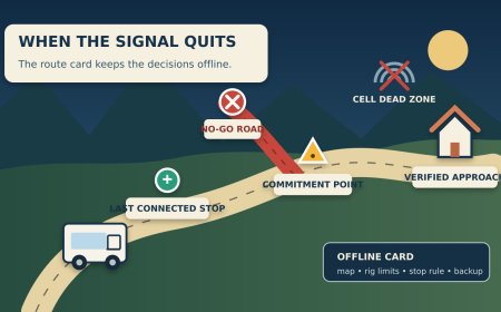
| Last connected stop | a legal pull-off where the crew will refresh alerts, fuel, weather, and messages |
| Commitment point | the last verified place to turn around, choose the alternate, or stop before the remote segment |
| No-go branch | road, gate, ford, tunnel, or unsigned shortcut that must not be used |
| Arrival cue | mileage from a durable landmark, entrance side of road, and a coordinate written in decimal degrees |
| Backup | verified alternate stop or return point, plus the condition that triggers it |
| Contacts | campground, ranger district or field office, road agency, and emergency number as appropriate |
The commitment point deserves the most care. It might be a fuel station before a canyon road, a visitor center before an unpaved spur, or a junction where the legal alternate continues straight. Give it a plain instruction: "If the closure board is posted, turn back here" or "If arrival is later than 5:30, use Backup A." A vague note such as "check conditions" postpones the decision until the crew has fewer choices.
Download the exact place, then test it
Do not assume an app's presence means its content is stored. NPS says each park must be selected and downloaded for offline use; deleting or reinstalling the app does not transfer saved parks and lists.[1] BLM similarly says to download its georeferenced PDF before entering an area that may lack data coverage.[2]
Run an airplane-mode test while parked at home or at the last connected stop:
- Open the downloaded map without Wi-Fi or cellular data.
- Zoom to the remote road, entrance, alternate, and commitment point.
- Open every screenshot, reservation record, permit, and note you expect to use.
- Confirm the route card and phone numbers are stored on the device, not merely linked from email or cloud storage.
- Put the device in the mount it will use and check that the charging cable reaches.
- Give the passenger or second driver a separate copy.
This catches a surprisingly ordinary failure: the map was viewed, but never downloaded. It also catches a document that opens only while the cloud account is online.
Battery belongs in the test. BLM notes that phones may drain faster where there is no cellular reception and says airplane mode can improve battery life without interfering with GPS tracking.[2] Grand Canyon's NPS page also warns that continued background GPS use can reduce battery life.[3] An RV has more charging options than a backpack, but a cable in the wrong cab, a dead 12-volt outlet, or a phone used for photos can still remove the only working map.
Keep the legal map separate from the convenient map
On public land, a pretty recreation map may not be the document that controls motor-vehicle use. The route card should name the map and its job: "NPS park map for entrance and facilities," "BLM georeferenced PDF for position," or "current motor-vehicle-use map for legal road status." If the agency provides a travel-management map or local order, save that exact document as well.
Coordinates need the same discipline. A pin can mark a campsite, office, or road junction, but it does not promise an RV-safe approach. Write the intended access road next to the coordinate. If two roads reach the same pin and one is unsuitable, list the bad approach under "no-go branch." This prevents the navigation app from quietly choosing a shorter road after a missed turn or recalculation.
Never improvise a shortcut because the location dot appears close to the destination. A dot shows position, not bridge capacity, road ownership, gate status, grade, surface, or turnaround room. BLM explicitly says its georeferenced maps are not a substitute for preparation and local current-condition information.[2]
Refresh the live layer before it disappears
Ready.gov advises travelers to plan long trips carefully and follow current weather forecasts and road conditions.[4] Put that advice on the clock. The final live check should happen at a named place, not "somewhere before service drops."
At the last connected stop:
- open the relevant state 511 or road-agency page;
- open the land manager's alerts and closure page;
- check the forecast for the remote segment and destination;
- call if the official page says conditions are uncertain or the access road is locally managed;
- take a dated screenshot of the result;
- compare remaining fuel and daylight with the commitment point;
- tell the off-route contact which road and campground you are using.
The screenshot is a record of what was known at that moment, not continuing proof. If a sign, barricade, ranger, law-enforcement officer, or road crew gives newer information, follow the current instruction. Do not use the saved screen to argue with a closed gate.
Make the backup specific
"Turn around if needed" is not a backup. It is an admission that the backup was never planned.
Name a reachable place, the route back to it, and the minimum fuel or daylight needed to get there. Check whether the rig can enter and leave it. If the alternate is an overnight stop, verify permission and hours instead of assuming a large parking lot is available. If the remote segment has no safe turnaround, move the commitment point back to the last junction that does.
The route card should also state who makes the call. With two adults in the cab, one person can monitor the offline map and card while the driver watches the road. Solo drivers should pull into a legal, stable stopping place before reading details or changing the route. Never stop in a travel lane or use a narrow shoulder as a planning desk.
Ready.gov includes a map, charger, reflective warning device, blanket, and other basics in its vehicle emergency-kit guidance.[4] An RV-specific kit can add a printed route card, rig dimensions, roadside-assistance details, and the campground's exact access instructions. The paper copy is not old-fashioned when the phone is overheated, dropped, dead, or needed for an emergency call.
The five-minute handoff before the dead zone
Before leaving the last connected stop, say the plan aloud:
- "We stay on State Route 12 to County Road 4."
- "The old mine road is the no-go turn."
- "The commitment point is the ranger station."
- "If the gate notice says closed, we return to the junction and use the verified overnight stop."
- "The map and route card both open in airplane mode."
That short handoff gives the crew a shared route, a shared stop rule, and a shared fallback. The signal may disappear. The decisions do not have to disappear with it.
Sources
- National Park Service: App 101 — Tips and Tricks — offline park downloads, saved lists, Wi-Fi advice, and transfer limitations; accessed October 9, 2026.
- Bureau of Land Management: Georeferenced PDF Maps — offline GPS map use, download requirements, battery and accuracy cautions, and preparation disclaimer; accessed October 9, 2026.
- National Park Service: Visit Grand Canyon with the NPS Mobile App — limited connectivity, offline content, real-time-update exception, and GPS battery warning; accessed October 9, 2026.
- Ready.gov: Car Safety — long-trip planning, current weather and road conditions, and vehicle emergency-kit guidance; accessed October 9, 2026.
What's Your Reaction?