






Pick the Right U.S.-Canada Border Crossing for Your RV
Choose a U.S.-Canada RV border crossing by current port hours, direction-specific wait times, rig fit, a last safe decision point and a workable backup port.

Pick the Right U.S.-Canada Border Crossing for Your RV
By Romana | October 7, 2026
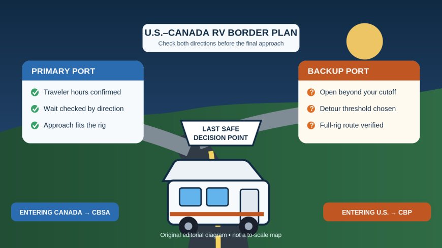
A border pin on a navigation app is not a complete crossing plan. An RV needs a port that is open in the direction and time you will arrive, an approach that fits the rig, and enough schedule margin for a changing queue. Choose a primary port and a realistic backup before departure, then recheck both shortly before you commit to the final approach.
Source note: This guide was built from current U.S. Customs and Border Protection (CBP) and Canada Border Services Agency (CBSA) planning tools. It covers port choice, operating hours and wait-time checks, a different intent from our earlier food, firewood, pet-record and declaration guides.
Start with direction, not the nearest map pin
The same physical crossing has two government checkpoints. Going north, CBSA controls entry into Canada. Returning south, CBP controls entry into the United States. Treat those as separate trip legs, even if you expect to use the same bridge or road both ways.
For a Canada-bound leg, CBSA tells land travelers to check both its border-wait page and its official office directory for port hours. It also suggests considering a less busy nearby port and comparing navigation routes rather than accepting the first GPS result.[1] For a U.S.-bound leg, use CBP's port locator to identify the U.S. port record, then open the specific port information rather than relying on a third-party pin.[4]
Write the official names of both sides of the crossing in your trip note. Border pairs do not always share one obvious name, and a nearby commercial crossing, traveler crossing, bridge or tunnel can appear as a separate map result. Record the road or bridge name too. This small step makes it much harder to check one port and accidentally drive to another.
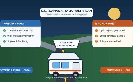
Build a two-port card
Make one card for the primary crossing and one for the backup. A phone note is enough. Give each card these fields:
- Canadian port name and official CBSA listing
- U.S. port name and official CBP listing
- traveler or passenger-vehicle hours for your planned date
- time zone used at the crossing
- road, bridge or tunnel operator page, when applicable
- current traveler wait in the direction you are driving
- last practical turnoff where you can still choose the backup
- campground, fuel or rest stop that remains reachable if the crossing takes longer than expected
The hours line deserves care. A port complex may publish different schedules for travelers, commercial traffic or a trusted-traveler lane. Your RV is not a commercial truck merely because it is large. Read the schedule for the lane and service you actually intend to use, and contact the port when the listing does not clearly cover your vehicle or arrival.
Do not infer that the return schedule matches the outbound schedule. In 2025, CBP and CBSA aligned hours at many northern ports, but CBP's announcement also listed seasonal hours, weekday-only operation and holiday closures at particular locations.[5] That history is a practical warning, not a substitute for today's listing. Recheck current records for the exact date and direction.
Ask the fit questions before choosing the “quieter” port
A short queue does not help if the approach is wrong for your rig. The border-agency directory is only one layer of the check. For a bridge, tunnel or toll crossing, also read the facility operator's current vehicle restrictions and traffic notices. Check the route from the last safe pull-off through the inspection plaza, not just the highway leading toward it.
Use your loaded travel dimensions: total combination length, maximum height, width, axle or weight limits if relevant, and turning needs. Then settle five questions:
- Does this location process ordinary travelers and passenger vehicles when you plan to arrive?
- Is the approach legal and workable for your RV's dimensions and equipment?
- Does the facility operator publish a restriction that affects propane, oversize vehicles, trailers or lane choice?
- Can you wait in the vehicle without creating a pet, fuel or medical problem?
- If the port closes or traffic stops, where can the full rig turn around or pause legally?
Call the port or facility operator when an official page leaves one of those questions unresolved. A vague online answer should not become a confident routing assumption.
Use wait-time pages for the correct direction
CBSA's land-border page reports traffic entering Canada at 30 busy crossings. It separates commercial flow from traveler flow and warns that its estimates do not include delays on roads approaching the port.[2] That means a favorable traveler figure is useful, but it is not an arrival promise. Construction, a bridge backup or an incident before the plaza can add time that the border estimate does not show.
For entry into the United States, use CBP's Border Wait Times tool and select the Canadian-border port, passenger-vehicle crossing and appropriate lane. Do not carry a Canada-bound CBSA number over to the U.S.-bound drive. The two agencies are measuring different queues.
Check in stages:
- The evening before, confirm hours and screen for construction or closure notices.
- Before departure, compare the primary and backup routes using the full-rig drive time, not car-only intuition.
- At the last safe decision point, refresh the destination country's official wait-time page and the bridge, tunnel or local traffic notice.
- Once committed to the plaza approach, follow signs and officer directions instead of trying to improvise a queue escape.
Save a screenshot or note the update time only as a travel record. Always refresh the live page before making a decision. CBSA says estimates can change with holidays, major events and enforcement activity, and its table shows when each entry was updated.[2]
Give the backup port a real threshold
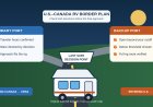
“Use the other crossing if this one is bad” is not a plan. Choose a threshold while parked, when nobody is trying to interpret a map in traffic.
Suppose the backup adds 35 minutes of driving. Switching for a posted 20-minute queue would probably lose time, especially because the posted estimate omits the approach road. A 90-minute queue plus a reported bridge backup may justify the detour, provided the backup is open long enough and its route fits the RV. The exact threshold is yours; the useful part is deciding it before the interchange.
Also set an arrival cutoff. If the primary closes at 8 p.m., do not plan to reach the border at 7:55. Allow for fuel, traffic, a wrong lane and the possibility that the backup closes earlier. If neither port has enough margin, stop on the originating side and cross the next day. A campsite reservation is not a reason to race a closing port.
Direction-specific departure checks
Driving into Canada
Open the CBSA office directory and confirm the Canadian port's current traveler hours. The directory states that it is updated regularly and gives the Border Information Service number for questions about offices and services.[3] Then check CBSA's Canada-bound wait page and any linked pre-border traffic source. Keep the Canadian port name, U.S. counterpart and backup crossing in the same note.
Driving into the United States
Open the U.S. port through CBP's locator, confirm the relevant port information, and check CBP's Canada-border wait tool for passenger vehicles. Verify facility restrictions separately when a bridge, tunnel or toll authority controls the approach. Recheck the return leg even if you crossed north only a few days earlier.
These routing checks do not replace entry-document, declaration, food, firewood, pet or equipment research. They answer a narrower question: whether the chosen crossing is available and practical for the rig at the planned time. Rules and operating details can change in either direction. Recheck the exact current requirements with the receiving border agency and the crossing operator before each leg.
The 15-minute predeparture check
Before pulling away from the last comfortable RV stop, park and do one final review:
- primary and backup ports are open past your realistic arrival time;
- the displayed wait belongs to traveler traffic in your direction;
- the update timestamp is recent enough to use;
- approach-road or facility notices show no new closure or restriction;
- the rig can use the planned route and crossing;
- everyone has water, medication and a restroom plan for a longer queue;
- your navigator knows the last safe decision point and the chosen threshold.
Then pick the port and stay with the decision unless new official information changes it. The goal is not to predict the exact minute you will reach the booth. It is to avoid arriving at a closed, unsuitable or unexpectedly inaccessible crossing with a long RV and nowhere sensible to go.
Sources
- CBSA: Border reminder checklist — direction-specific planning, documents and declaration reminders; accessed October 7, 2026.
- CBSA: Border wait times, United States to Canada — Canada-bound traveler flow, update times and limits of the estimate; accessed October 7, 2026.
- CBSA: Directory of Offices and Services — current directory pointer and Border Information Service contact; accessed October 7, 2026.
- CBP: Locate a Port of Entry — official U.S. port lookup; accessed October 7, 2026.
- CBP: Northern border port hours adjustment — examples of permanent, seasonal, weekday and holiday operating schedules effective in 2025; accessed October 7, 2026.
What's Your Reaction?